Currently Empty: 0,00 €
Historical Nineteenth-Century Map of Bolivia This antique color map displays a comprehensive 1894 geographical overview of Bolivia, published by Wm. M. Bradley and Co. in Philadelphia. The cartography outlines ...
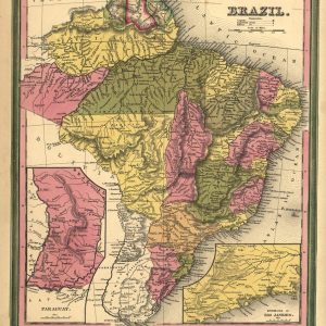
Mid-nineteenth century cartography of Imperial Brazil This antique 1846 map depicts Brazil during its imperial era, showcasing detailed provincial boundaries and distinct hand-colored regions. Published in Philadelphia, the document ...
Historical cartography of the Brazilian Empire This antique 1823 map shows the territorial division of Brazil shortly after its independence. It highlights the early imperial provinces, coastal regions, and ...
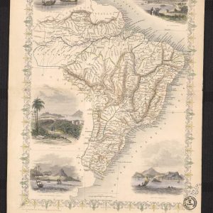
Nineteenth-Century Imperial Brazil Cartography Immerse your space in the historical grandeur of South America with this masterfully restored 1851 map of Brazil, published by the legendary Victorian cartographer John ...

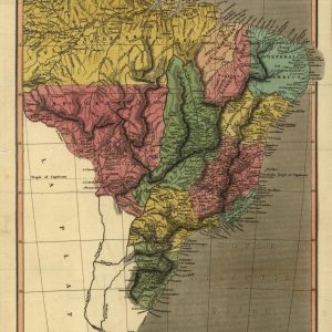
Historical 1828 cartographic map of Brazil and Paraguay This antique engraved map displays a detailed 1828 geographic perspective of Brazil and Paraguay, covering a vast expanse of South America ...
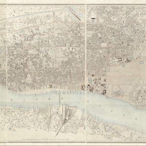
Historical Colonial Survey Map of Calcutta This exceptional antique lithograph represents the comprehensive historical survey of Calcutta, India, executed between 1847 and 1849 by civil engineer Frederick Walter Simms. ...
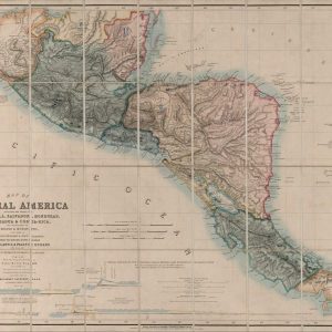
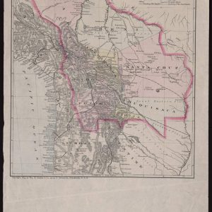
Historical Nineteenth-Century Map of Central America This antique lithograph showcases a landmark 1850 geographical map of Central America, drawn from original documents by engineer John Baily. The comprehensive cartography ...

Historical 1897 Map of China and Southeast Asia This vintage 1897 map by Rand McNally & Co. provides a detailed cartographic overview of East and Southeast Asia at the ...
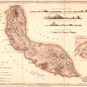
Historical Cartography of Curacao and Dutch Caribbean Settlements This exquisite antique maritime chart delineates the island of Curacao, compiled based on the authoritative Dutch originals by cartographer Gerard van ...
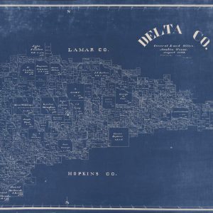
Nineteenth-Century Land Registry Blueprint of Delta County TX This rare historical cianotype, or blueprint map, dates back to August 1889 and represents an official survey from the General Land ...
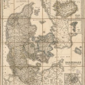
Nineteenth-Century German Cartography of Denmark and the Baltic This detailed antique map, titled “Daenemark mit seinen Nebenlaendern in Europa,” was drawn by C.F. Weiland and published in 1856 by ...
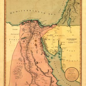
Historical Geography of Egypt and the Levant This authentic 1803 regional map offers a detailed cartographic view of Northeast Africa and the Middle East during the early nineteenth century. ...
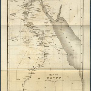
Historical Cartography of the Antique Map of Egypt and the Nile River This beautifully preserved 1844 antique map showcases the geography of Egypt, Nubia, and the surrounding regions, including ...
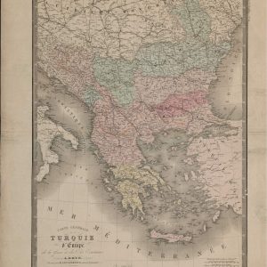
19th-Century French Cartography of the Balkan Peninsula This remarkable historical document offers an intricate look at the southeastern European territories under Ottoman influence, historically referred to as European Turkey. ...
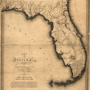
Historical Survey Map of Florida Territory This exceptional antique cartography displays the landmark 1823 map of Florida, compiled and drawn by civil and topographical engineer Charles Vignoles. Published shortly ...
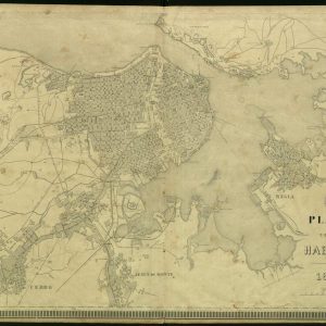
Historical Nineteenth-Century City Plan of Havana This antique lithograph features an intricate 1875 architectural and urban layout of Havana, Cuba, titled Plano de la Habana. The vintage cartography showcases ...
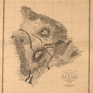
Historical Government Survey Map of Hawaii Island This detailed 1886 topographical map shows the Big Island of Hawaii, created by the Hawaiian Government Survey. It illustrates the coastal geography, ...
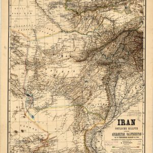
Nineteenth-Century German Cartography of the Middle East and Central Asia This highly detailed antique map, titled “Iran Östliche Hälfte,” was drafted by the renowned German cartographer Heinrich Kiepert and ...
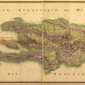
Historical 1803 French Map of Saint Domingue Island This antique cartographic document presents a detailed topographical map of the island of Saint Domingue, known today as Hispaniola, drawn in ...
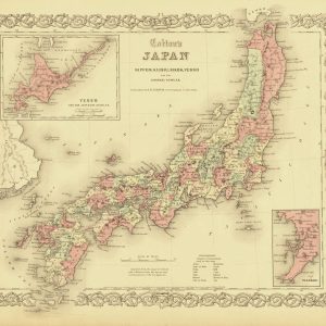
Nineteenth-Century American Cartography of the Japanese Archipelago Published in 1855 by J.H. Colton, this rare antique map offers a detailed geographical survey of Japan during a transformative period of ...
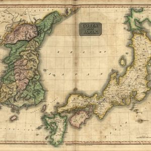
Early Nineteenth-Century Cartography of the Korean Peninsula and Japan This authentic antique map, engraved by Kirkwood and published in 1815 for John Thomson’s New General Atlas, offers a detailed ...

Historical Map of Liberia and West Africa Coast This 19th-century historical map shows the Republic of Liberia and its vicinity along the West African coast. It features coastal settlements ...
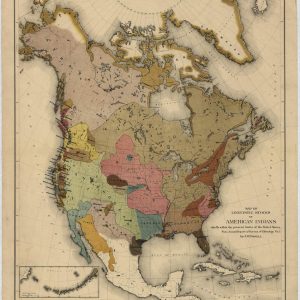
Historical Ethnographic Map of Native American Languages This antique color lithograph represents the seminal 1891 cartographic work by John Wesley Powell, depicting the linguistic stocks of American Indians. Published ...
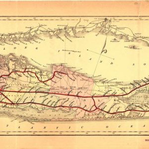
Historical Map of the Long Island Railroad Network This antique lithograph showcases a specialized 1882 geographical map of Long Island, New York. The cartography focuses specifically on detailing the ...