Currently Empty: 0,00 €
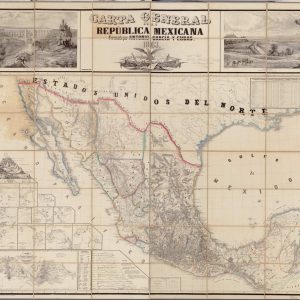
Historical 1863 Cartography of the Mexican Republic This antique cartographic masterpiece showcases the official 1863 geographical layout of Mexico, precisely drafted by the renowned surveyor Antonio García y Cubas. ...

Historical French Cartography of the Australian Continent This antique map presents a comprehensive view of Australia, labeled with historical French terminology as part of the “Grand Archipel D’Asie”. The ...
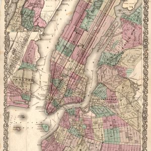
Nineteenth-Century Urban Cartography of Greater New York This exceptional antique map, published by J.H. Colton, captures the dense urban development of New York City and its surrounding municipalities during ...
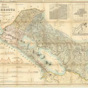
Historical 1859 Map of the Republic of Nicaragua This rare historical document displays the official map of the Republic of Nicaragua, commissioned by the government and drawn by Maximilian ...
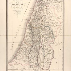
Nineteenth-Century Cartography of Palestine and the Holy Land This authentic 1851 steel-engraved chart, compiled by French geographers Pierre Lapie and son, provides an intricate depiction of historical Palestine. The ...
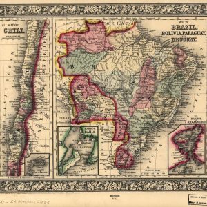
Historical Nineteenth-Century Map of South American Nations This antique color lithograph represents a highly detailed 1865 map of Brazil, Bolivia, Paraguay, Uruguay, and Chile. Published by Samuel Augustus Mitchell ...
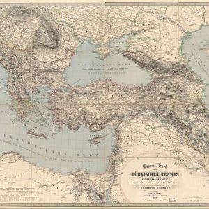
Historical Cartography of the Ottoman Empire This antique map details the vast territorial expansion of the Ottoman Empire during the 19th century, covering strategic regions across Eastern Europe, the ...
Historical Woodblock Cartography of the Great Qing Empire This remarkable antique Chinese map, historically titled as the complete map of the Great Qing Dynasty, represents a classic example of ...
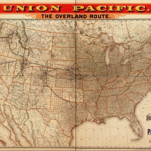
Chart the Iron Trails of the American Transcontinental Railroad Relive the legendary golden age of steam travel with this high-fidelity reproduction of the iconic 1892 Union Pacific Railroad map. ...

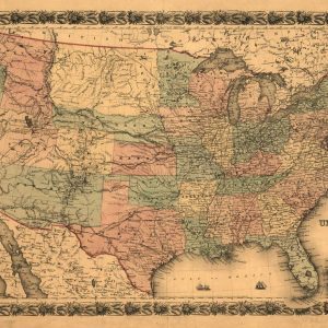
Pre-Civil War Political Map of the United States This powerful 1857 historical chart illustrates the critical geopolitical division of America leading up to the Civil War. Titled as a ...
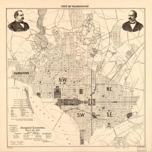
Late Nineteenth-Century Urban Layout of Washington DC This historic street map, published specifically for the Presidential Inaugural Ceremonies on March 4th, 1893, provides a detailed topographical and civic overview ...
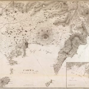
Topographical Survey of the Gulf of Naples and Mount Vesuvius This exquisite 1828 regional chart provides an authentic look at the coastal geography surrounding Southern Italy. The monochrome lithograph ...
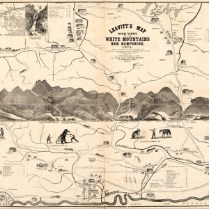
Leavitt’s Historical Map of the White Mountains This 1871 illustrated map showcases the scenic White Mountains region of New Hampshire. Created by Franklin Leavitt, it highlights early railroad routes, ...
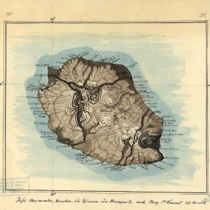
Discover the Historical Cartography of the Indian Ocean Travel back in time with this stunning artistic reproduction of an antique map of Reunion Island. This piece meticulously details the ...
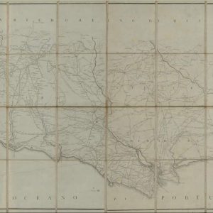
Strategic Defense Routes and Trans-Iberian Communication Lines This comprehensive archival cartographic print highlights the primary networks of strategic roads and defensive communication lines crossing the Portuguese kingdom. Designed specifically ...
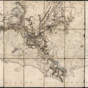
Nineteenth-Century Military Topography and Defensive Cartography of Portugal This exceptional antique military map, titled “Carta Militar das Principais Estradas de Portugal,” delivers an authoritative geographical and tactical survey of ...
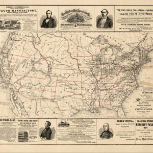
Civil War Era Cartography and United States Military Defenses Published in 1861 by J.H. Colton, this exceptional antique map delineates the United States at the pivotal outbreak of the ...
Historical 19th-century Lloyd’s American railroad map of the United States This vintage 1861 railroad map offers a comprehensive geographic overview of the United States transport network prior to the ...
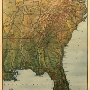
Richmond & Danville Railroad and the Florida Central & Peninsular Systems and their connections Bring history to life with this high-quality reproduction of the 1893 Richmond and Danville Railroad ...
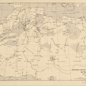
Explore the Historic Trade Routes of the Sahara Delve into the age of exploration with this fascinating 1889 cartographic chart detailing the major commercial routes across the Sahara Desert. ...
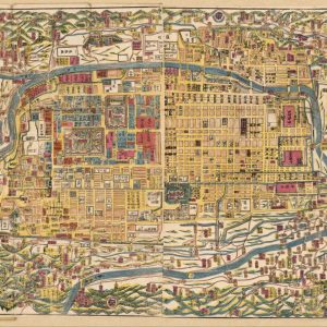
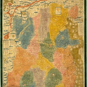
元治新撰皇都細見圖 | Kōto saikenzu Street map of Kyoto, showing temples, shrines, palaces, mansions, etc. Relief shown pictorially in surrounding area. Japanese. Panel title. Oriented with north to the left. ...

Satirical Map of Europe During the Franco-Prussian War This 1870 satirical caricature map portrays European nations as humorous and aggressive figures during the Franco-Prussian War. Titled as Europe seen ...
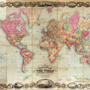
Nineteenth-Century Global Cartography on Mercators Projection This magnificent antique world map, published by J.H. Colton, represents a peak example of mid-nineteenth-century American commercial cartography. Utilizing Mercator’s projection, the hand-colored ...