Currently Empty: 0,00 €
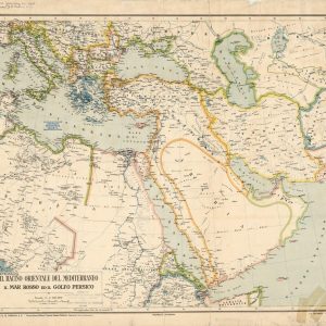
Historic Nineteenth-Century Italian Cartography Travel back to the late Victorian era with this beautiful reproduction of the 1890 map of the Middle East, titled “Il Bacino Orientale del Mediterraneo ...
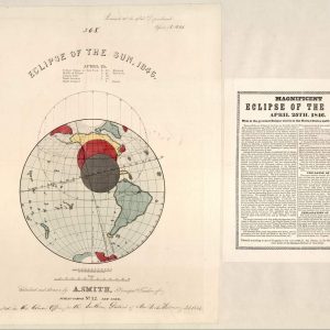
Nineteenth-Century Astronomical Chart of the 1846 Solar Eclipse This rare historical broadside captures the scientific documentation of the total solar eclipse that occurred on April 25, 1846. Designed and ...
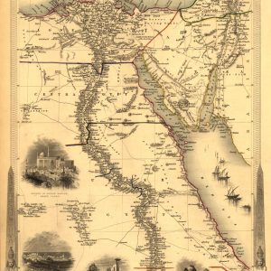
Victorian Cartography of the Nile Valley and Sinai Published in 1851 by John Tallis, this beautifully engraved antique map delineates the territories of Lower, Central, and Upper Egypt alongside ...
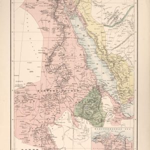
Cartography of Northeast Africa and the Red Sea This vintage nineteenth-century map provides a comprehensive geographical overview of the Nile Valley, Eastern Soudan, and Abyssinia. The detailed illustration traces ...

Mid-Nineteenth-Century Political Cartography of the European Continent Published in Philadelphia by S. Augustus Mitchell for his “New Universal Atlas” in 1849, this authentic antique map captures the geopolitical alignment ...
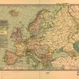
Late Nineteenth-Century Imperial Cartography of Europe Published in New York for “The Century Atlas” in 1897, this detailed vintage map documents the political geography of the European continent at ...
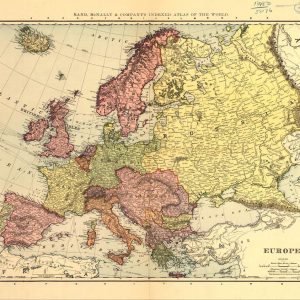
Late Victorian Cartography of the European Continent Published in Chicago by Rand, McNally & Company for their “Indexed Atlas of the World” in 1898, this authentic vintage map presents ...
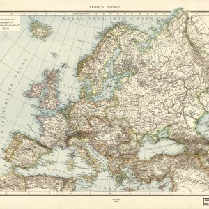
Antique German Topographical Map of the European Continent This historical map provides a comprehensive overview of Europe, featuring detailed cartography with German nomenclature. The vintage document beautifully highlights the ...
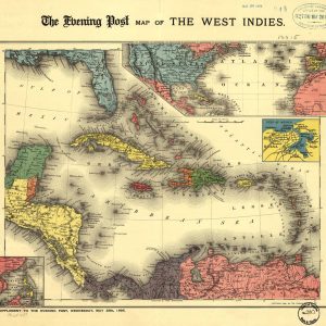
Historic Spanish-American War Era Cartography Step into a defining moment of global history with this faithful reproduction of the 1898 Evening Post map of the West Indies. Published as ...

19th-Century Maritime View of Fort Monroe and Old Point Comfort This dramatic antique lithograph offers a spectacular panoramic perspective of Fort Monroe, Old Point Comfort, and the legendary Hygeia ...
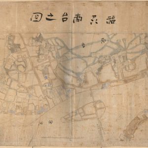
19th-Century Bilingual Survey of Foo-Chow This exceptional 1888 antique map provides a detailed urban layout of the foreign properties and concessions within Foo-Chow (Fuzhou), China. Created during a pivotal ...

Joseon Dynasty Cartography of Historical Korea This exquisite antique manuscript chart captures the traditional cartographic heritage of the Korean Joseon Dynasty. Rather than using rigid geometric surveys, this historical ...
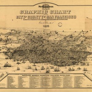
A Historical Window into 1875 San Francisco Travel back in time with this magnificent panoramic illustration capturing the essence of 19th-century San Francisco. Originally published as a special newspaper ...
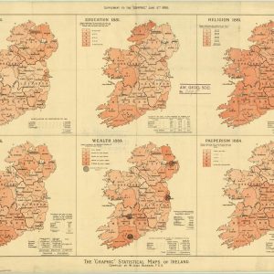
Victorian Thematic Infographics and Demographic Analysis of Ireland This rare 1886 colored lithograph chart showcases an advanced piece of Victorian data visualization, presenting a comprehensive demographic audit of the ...
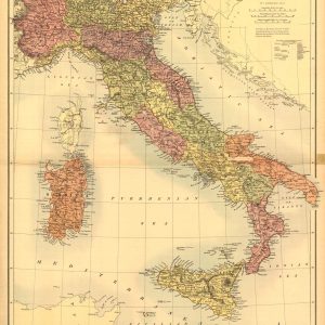
Nineteenth-Century Scottish Cartography of the Italian Peninsula Published in Edinburgh by Adam & Charles Black, this exceptional antique map offers a highly detailed geographical survey of Italy during the ...

Nineteenth-Century Cartography of the Empire of Brazil and Guayana Published in 1871 by G.W. & C.B. Colton, this authentic antique map offers a detailed geographical survey of South America ...
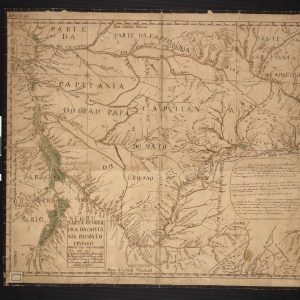
18th-Century Cartography of Colonial Brazil This historical manuscript map outlines the expansive territorial boundaries of the Captaincy of Mato Grosso during the Portuguese colonial era. Meticulously detailed to represent ...
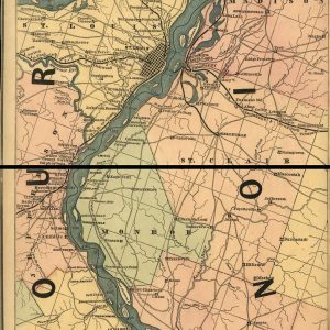
Historical 1862 Lloyd’s map of the lower Mississippi River This vintage American Civil War era map provides a detailed topographic view of the lower Mississippi River corridor, extending from ...
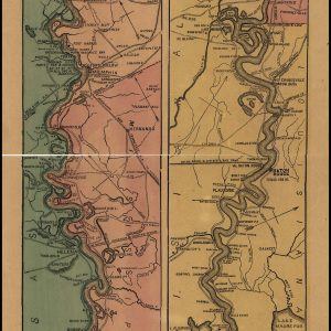
A Vertical Masterpiece of the 1862 Mississippi River Immerse your space in American history with this remarkable 1862 fluvial chart mapping the Mississippi River from Cairo, Illinois, down to ...
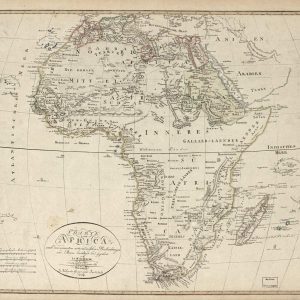
Nineteenth-Century German Cartography of the African Continent This remarkable antique map, titled “Charte von Africa,” was drafted by the German cartographer J.C.M. Reinecke and published in Weimar by the ...
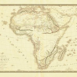
Historical Cartography of the African Continent This antique French map titled Carte de l’Afrique displays the geographical contours of the continent. It highlights major historical regions like the Sahara ...
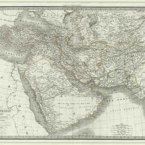
Historical 19th-century map of the Middle East and Southern Asia This detailed antique map focuses on the historic geography of Asiatic Turkey, Persia, Afghanistan, and Arabia. Drawn during the ...
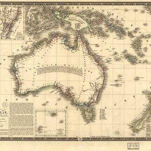
Historical French Cartography of Australia and Oceania This antique French map provides a detailed cartographic view of Australia, titled as part of the southwest region of Oceania. The vintage ...
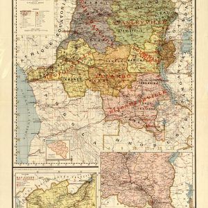
Historical Cartography of the Belgian Congo Region This antique French map displays the colonial territory of the Belgian Congo, showcasing its administrative boundaries and regional divisions. The color-coded document ...