Currently Empty: 0,00 €
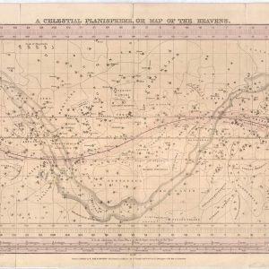
Chart the Night Sky with 19th-Century Astronomy Embark on a cosmic journey back to the early nineteenth century with this rare reproduction of F.J. Huntington’s “A Celestial Planisphere.” This ...
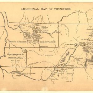
Uncover the Ancestral Frontiers of Early Tennessee Delve deep into Southern history with this compelling reproduction of the 1888 “Aboriginal Map of Tennessee.” This specialized cartographic study illustrates the ...

Abraham Lincoln, three-quarter length portrait, seated, facing right. Abraham Lincoln, one of America’s most iconic leaders, continues to inspire the world with his unwavering dedication to freedom, equality, and ...
Maps of Alaska, from approximately 1568 to 1880 – AK Drawer 01 Folder 04. Source Collection Library of Congress Geography and Map Division Washington, D.C. 20540-4650 USA dcu
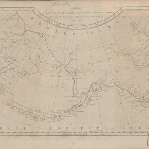
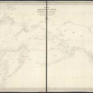
Maps of Alaska, from approximately 1568 to 1880 – Drawer 01 maps. Source Collection Library of Congress Geography and Map Division Washington, D.C. 20540-4650 USA dcu

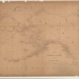
Maps of Alaska, from approximately 1568 to 1880 – AK Drawer 01 Folder 12a Item 01. Source Collection Library of Congress Geography and Map Division Washington, D.C. 20540-4650 USA ...
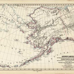
Maps of Alaska, from approximately 1568 to 1880 – AK Drawer 01 Folder 06. Source Collection Library of Congress Geography and Map Division Washington, D.C. 20540-4650 USA dcu
Maps of Alaska, from approximately 1568 to 1880 – AK Drawer 01 Folder 22. Source Collection Library of Congress Geography and Map Division Washington, D.C. 20540-4650 USA dcu
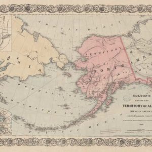
Maps of Alaska, from approximately 1568 to 1880 – AK Drawer 01 Folder 17 Item 01. Source Collection Library of Congress Geography and Map Division Washington, D.C. 20540-4650 USA ...

Anatomy Class – Brick and stone building located at the corner of 12th and Pacific Streets, Omaha, Nebraska Credit: University of Nebraska Medical Center
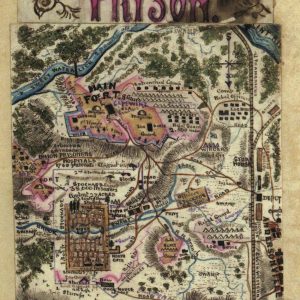
A Rare Eyewitness Cartographic Account of the American Civil War Immerse your historical collection in the raw reality of the American Civil War with this extraordinary hand-drawn map reproduction ...
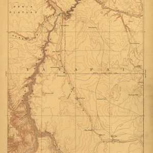
Discover the Rugged Topography of the Wild American West Bring the raw, untamed beauty of early American exploration to your walls with this exceptional 1886 reconnaissance map of the ...
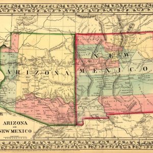
Trace the Historic Frontiers of the Old American Southwest Immerse your space in the legendary history of the American frontier with this vibrant 1867 map print of the Arizona ...

American Civil War Military Cartography and Strategic Fortifications This rare historical document serves as a tactical visual reference from the early years of the American Civil War, specifically detailing ...
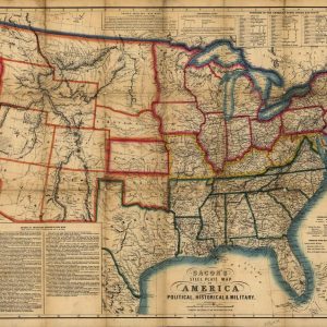
Historical Civil War Map of the United States This antique lithograph showcases a rare 1863 steel plate map of America, subtitled Political, Historical, and Military, published in London by ...
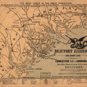
Historical Civil War Naval Map of Beaufort Harbor This antique 1862 map captures the strategic coastal region of Beaufort Harbor during the American Civil War, detailing the coastline between ...
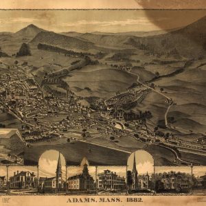
A Gilded Age Perspective of New England Valley History Capture the timeless appeal of historic New England with this masterfully restored 1882 bird’s-eye view map of Adams, Massachusetts. Nestled ...
A Panoramic Glimpse of Post-Civil War Michigan Architecture Immerse your space in the historical narrative of the American Midwest with this expertly restored 1866 panoramic map of Adrian, Michigan. ...
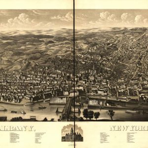
A Majestic Late-Nineteenth-Century Capital Skyline Immerse your space in the grandeur of New York’s state capital with this stunning 1879 bird’s-eye view map of Albany. This expansive panoramic illustration ...
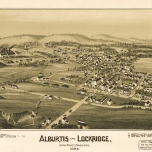
A Panoramic Glimpse of Pennsylvania’s Industrial Heritage Travel back to the late nineteenth century with this spectacular 1893 bird’s-eye view map of Alburtis and Lockridge, located in Lehigh County, ...
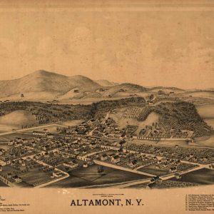
Rustic Sepia Charm of Late 19th-Century New York Bring the warmth of early American history into your home with this rare sepia-toned 1889 panoramic print of Altamont, New York. ...
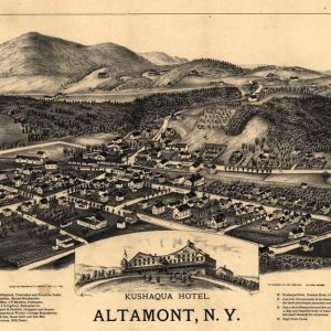
A Historic Escape to the Helderberg Mountains Travel back to the late nineteenth century with this captivating 1889 bird’s-eye view map of Altamont, New York, located in Albany County. ...
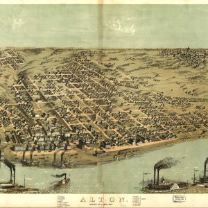
A Historic Glimpse of the Mississippi Riverfront Immerse your space in mid-nineteenth-century history with this panoramic 1867 illustration of Alton, Illinois, located in Madison County. This detailed bird’s-eye perspective ...
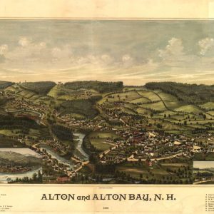
A Charming Glimpse of Nineteenth-Century New England Celebrate the scenic heritage of the Northeast with this beautifully restored 1888 panoramic map of Alton and Alton Bay, New Hampshire. Drawn ...