Currently Empty: 0,00 €
")
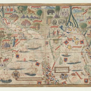
Nautical Atlas of the World, Folio 6 Verso, The Mediterranean Sea.
The map presented here is from the Miller Atlas in the collections of the National Library of France. Produced for King Manuel I of Portugal in 1519 by cartographers Pedro Reinel, his son Jorge Reinel, and Lopo Homem and miniaturist António de Holanda, the atlas contains eight maps on six loose sheets, painted on both sides.
This map (folio 6 verso in the atlas) shows the Mediterranean Sea. The region represented comprises the European coasts from Jutland to the Caucasus. The nomenclature starts at Frissa (Friesland) and runs across the southern coasts of England and Ireland. The Mediterranean and Atlantic coasts are shown as far west as Cape Bojador (Ansulim). Also shown are the Caspian Sea and the northern parts of the Red Sea and the Persian Gulf. The nomenclature that spreads out from the eastern coasts is in black and red cursive; the names of regions are in black capitals.
The names of provinces are in golden letters on red and blue streamers. The map contains very rich decoration similar to that in the other maps of the atlas: the Red Sea is shown in in red, the Caspian Sea and Persian Gulf in blue. Coasts are ringed with colors, islands with flat tints and gold. Rivers are in blue and green. Mountain ranges are shown in colors and in cavalier view. The map has about 50 miniatures of cities in cavalier view, with no apparent attempt at accuracy.
Other objects depicted are the cross of Golgotha overlooking Jerusalem, the Tables of the Law on Mount Sinai, and the Tower of Babel between the Tigris and Euphrates Rivers.
In Africa, eight tents with flags and four individuals are shown, one of whom is on horseback. On the oceans are eight vessels, five of which bear the Portuguese Cross of the Order of Christ. The map has red and gold borders on three edges. A scale of lengths in an upright position is displayed east of the Azores. The left edge of the map contains a scale of latitudes from 28° north to 59° north.
Each degree is divided into four parts with black dots and in three parts with red dots. The middle of each degree is indicated with a red circle. A draft of gradation in longitudes was attempted along parallels 33° 40′, 43° 30′ and 50° 50′ where degrees are respectively equivalent to 18 millimeters (mm), 16.3 mm, 14.7 mm, and 12 mm.
The origin of the longitudes lies outside of the map of the Mediterranean Basin, on the map of the Azores at 2° 16′ on the latitude scale, which is 2° from the meridian of Cape Saint Vincent. The atlas takes its name from Emmanuel Miller, who purchased it in 1855 from a bookseller in Santarém, Portugal. Miller’s widow sold it to the National Library of France in 1897.
Names
Holanda, António de, approximately 1480-1556 Illustrator.
Homem, Lopo, flourished 1517-1565 Cartographer.
Manuel I, King of Portugal, 1469-1521 Patron.
Reinel, Jorge, active 16th century Cartographer.
Reinel, Pedro, born approximately 1464 Cartographer.
Contributor: ?
Date: 1519
Reviews
Only logged in customers who have purchased this product may leave a review.
Delivery & return
Delivery & return
Next day delivery in store
Buy before 6pm to receive your order next day.FREE
Next day delivery
Orders before 6pm from Monday to Saturday (or before 1pm on Sunday) will be delivered Next working day (except Northern Ireland and Highlands). Orders placed after 6pm (after 1pm on Sunday) or for Northern Ireland and Highlands will be delivered in 2 working days.29 USD
Drop Point
In 2-3 working days. Pick up your parcel in one of the many diferent collection points available and during a wide range of hours.39 USD
Same day delivery in London:
Place your order before 13:00 to get it today!. If you order later on, you’ll receive it the next day and if you order on Sunday, you’ll receive it the next working day.59 USD
Shipping Info
Shipping Info
SHIPPING
Complimentary ground shipping within 1 to 7 business days In-store collection available within 1 to 7 business days Next-day and Express delivery options also available Purchases are delivered in an orange box tied with a Bolduc ribbon, with the exception of certain items See the delivery FAQs for details on shipping methods, costs and delivery timesComposition
Composition
Characteristics of wood :
- Hard, compact , fiberous and porous
- Good wood gives a rich, warm and beautiful surface.
Wood is used for the construction of:
- Floor, Furniture, Walls
- Incidental furnishing (lampshades, picture frames)
- Kitchen & restaurant ware
There are no reviews yet.