Currently Empty: 0,00 €

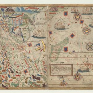
Nautical Atlas of the World, Folio 6 Recto, North Atlantic Ocean.
The map presented here is from the Miller Atlas in the collections of the National Library of France. Produced for King Manuel I of Portugal in 1519 by cartographers Pedro Reinel, his son Jorge Reinel, and Lopo Homem and miniaturist António de Holanda, the atlas contains eight maps on six loose sheets, painted on both sides.
This map (folio 6 recto in the atlas) shows the coast of Europe from Holland to Malaga and the African coast from Melilla (a Spanish enclave in northern Morocco) to Cape Palmas (present-day southeast Liberia), as well as the British Isles, the Azores, the Canary Islands, and the Cape Verde Islands.
The coasts of the Americas are shown in three sections: from Labrador to Acadia (present-day southeast Maine) with nomenclature for Newfoundland only (Terra Corte Regalis); from Virginia to the Gulf of the Mexico (Terra Bimenes, then an indigenous name for Florida), without nomenclature; and from the Yucatan and Cuba (Ante Ylläs) to the Mundus Novus (New World) of South America. The map has no rhumb lines, but only a grid corresponding to the north-south and east-west rhumbs.
There is no wind rose. The map is rich in nomenclature for the coast of Guyana and the West Indies. Nomenclature along the coasts is in black and red cursive script; nomenclature on the seas is in black capital letters. At the top, a wide cartouche shaped like a streamer is left blank; on its right, another scroll cartouche contains text. Close to Florida is another cartouche surrounded by a brown frame with threads of gold with a caption.
In Central America, there is a similar cartridge with the caption, Antilliarz ista In Castelle Regis parte / auri Mineralia inveniuntur (This [place called] Antilliarz is in the Kingdom of Castile / gold ores are found there). The map is rich in decoration. Mountains are seen in perspective. Landscapes with animals are shown in Africa, Acadia, and Florida. In Central America, dark-skinned natives are depicted hunting with arrows and working the soil.
Spanish flags and shields west of the center fold separate Newfoundland from Florida and Central America. Portuguese flags are planted on Newfoundland, along the African coast, and in Portugal; Spanish flags mark the Canary Islands. Nine of the 13 ships on the map fly the Portuguese Cross of the Order of Christ as they traverse the ocean.
The map is bordered on three sides by a red box outlined in black. The atlas takes its name from Emmanuel Miller, who purchased it in 1855 from a bookseller in Santarém, Portugal. Miller’s widow sold it to the National Library of France in 1897.
Names
Holanda, António de, approximately 1480-1556 Illustrator.
Homem, Lopo, flourished 1517-1565 Cartographer.
Manuel I, King of Portugal, 1469-1521 Patron.
Reinel, Jorge, active 16th century Cartographer.
Reinel, Pedro, born approximately 1464 Cartographer.
Contributor: ?
Date: 1519
Reviews
Only logged in customers who have purchased this product may leave a review.
Delivery & return
Delivery & return
Next day delivery in store
Buy before 6pm to receive your order next day.FREE
Next day delivery
Orders before 6pm from Monday to Saturday (or before 1pm on Sunday) will be delivered Next working day (except Northern Ireland and Highlands). Orders placed after 6pm (after 1pm on Sunday) or for Northern Ireland and Highlands will be delivered in 2 working days.29 USD
Drop Point
In 2-3 working days. Pick up your parcel in one of the many diferent collection points available and during a wide range of hours.39 USD
Same day delivery in London:
Place your order before 13:00 to get it today!. If you order later on, you’ll receive it the next day and if you order on Sunday, you’ll receive it the next working day.59 USD
Shipping Info
Shipping Info
SHIPPING
Complimentary ground shipping within 1 to 7 business days In-store collection available within 1 to 7 business days Next-day and Express delivery options also available Purchases are delivered in an orange box tied with a Bolduc ribbon, with the exception of certain items See the delivery FAQs for details on shipping methods, costs and delivery timesComposition
Composition
Characteristics of wood :
- Hard, compact , fiberous and porous
- Good wood gives a rich, warm and beautiful surface.
Wood is used for the construction of:
- Floor, Furniture, Walls
- Incidental furnishing (lampshades, picture frames)
- Kitchen & restaurant ware
There are no reviews yet.