Currently Empty: 0,00 €

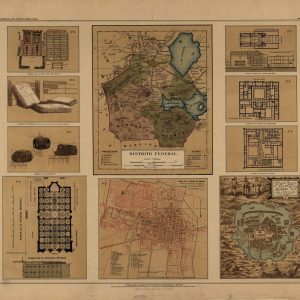
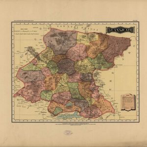
Atlas pintoresco é histórico de los Estados Unidos Mexicanos. Names García Cubas, Antonio, 1832-1912. Source Collection Library of Congress Geography and Map Division Washington, D.C. 20540-4650 USA dcu
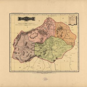
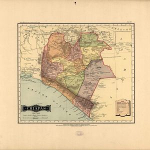
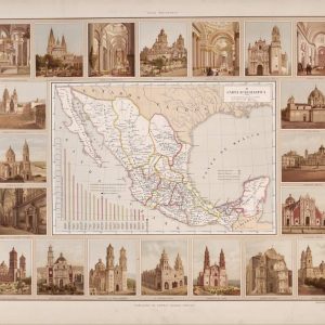
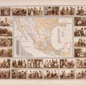
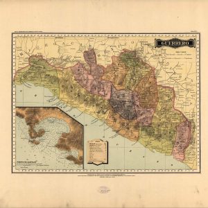
México, Debray Suc’s, c1884-86. Names García Cubas, Antonio, 1832-1912. Source Collection Library of Congress Geography and Map Division Washington, D.C. 20540-4650 USA dcu
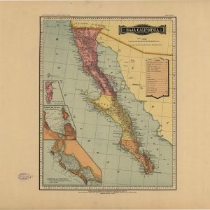
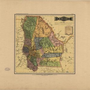
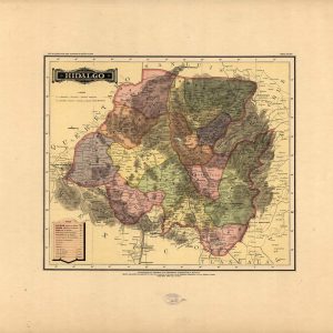
México, Debray Suc’s, c1884-86. Names García Cubas, Antonio, 1832-1912. Source Collection Library of Congress Geography and Map Division Washington, D.C. 20540-4650 USA dcu
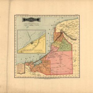
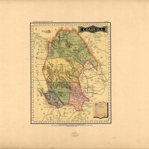
México, Debray Suc’s, c1884-86. Names García Cubas, Antonio, 1832-1912. Source Collection Library of Congress Geography and Map Division Washington, D.C. 20540-4650 USA dcu
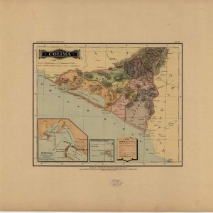
México, Debray Suc’s, c1884-86. Names García Cubas, Antonio, 1832-1912. Source Collection Library of Congress Geography and Map Division Washington, D.C. 20540-4650 USA dcu
México, Debray Suc’s, c1884-86. Names García Cubas, Antonio, 1832-1912. Source Collection Library of Congress Geography and Map Division Washington, D.C. 20540-4650 USA dcu
México, Debray Suc’s, c1884-86. Names García Cubas, Antonio, 1832-1912. Source Collection Library of Congress Geography and Map Division Washington, D.C. 20540-4650 USA dcu
México, Debray Suc’s, c1884-86. Names García Cubas, Antonio, 1832-1912. Source Collection Library of Congress Geography and Map Division Washington, D.C. 20540-4650 USA dcu
México, Debray Suc’s, c1884-86. Names García Cubas, Antonio, 1832-1912. Source Collection Library of Congress Geography and Map Division Washington, D.C. 20540-4650 USA dcu
Atlas pintoresco é histórico de los Estados Unidos Mexicanos. Names García Cubas, Antonio, 1832-1912. Source Collection Library of Congress Geography and Map Division Washington, D.C. 20540-4650 USA dcu
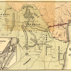
Nineteenth-Century Railroad Infrastructure and Texas Borderlands This historical map, published in 1873 for the Corpus Christi and Rio Grande Railway Company, documents the strategic transportation routes connecting South Texas ...
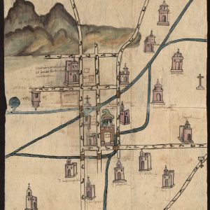
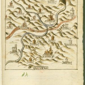
This map from Culhuacán in the present-day Delegación de Ixtapalapa, Mexico City, is from the Relaciones Geográficas collection in the Benson Latin American Collection at the University of Texas ...
México, Debray Suc’s, c1884-86. Names García Cubas, Antonio, 1832-1912. Source Collection Library of Congress Geography and Map Division Washington, D.C. 20540-4650 USA dcu
Atlas pintoresco é histórico de los Estados Unidos Mexicanos. Names García Cubas, Antonio, 1832-1912. Source Collection Library of Congress Geography and Map Division Washington, D.C. 20540-4650 USA dcu
Atlas pintoresco é histórico de los Estados Unidos Mexicanos. Names García Cubas, Antonio, 1832-1912. Source Collection Library of Congress Geography and Map Division Washington, D.C. 20540-4650 USA dcu
México, Debray Suc’s, c1884-86. Names García Cubas, Antonio, 1832-1912. Source Collection Library of Congress Geography and Map Division Washington, D.C. 20540-4650 USA dcu
México, Debray Suc’s, c1884-86. Names García Cubas, Antonio, 1832-1912. Source Collection Library of Congress Geography and Map Division Washington, D.C. 20540-4650 USA dcu
México, Debray Suc’s, c1884-86. Names García Cubas, Antonio, 1832-1912. Source Collection Library of Congress Geography and Map Division Washington, D.C. 20540-4650 USA dcu
México, Debray Suc’s, c1884-86. Names García Cubas, Antonio, 1832-1912. Source Collection Library of Congress Geography and Map Division Washington, D.C. 20540-4650 USA dcu
Atlas pintoresco é histórico de los Estados Unidos Mexicanos. Names García Cubas, Antonio, 1832-1912. Source Collection Library of Congress Geography and Map Division Washington, D.C. 20540-4650 USA dcu
This map from Ixcatlán, Santa María, in the present-day state of Oaxaca, Mexico, is from the Relaciones Geográficas collection in the Benson Latin American Collection at the University of ...
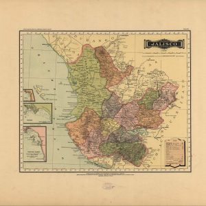
México, Debray Suc’s, c1884-86. Names García Cubas, Antonio, 1832-1912. Source Collection Library of Congress Geography and Map Division Washington, D.C. 20540-4650 USA dcu
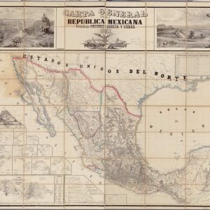
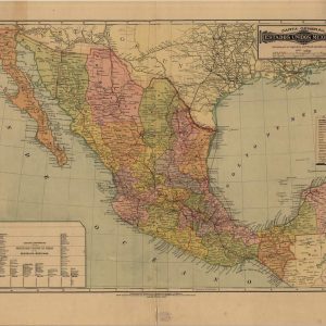
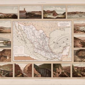
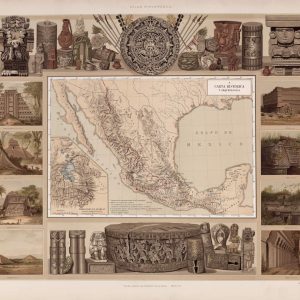
Historical 1863 Cartography of the Mexican Republic This antique cartographic masterpiece showcases the official 1863 geographical layout of Mexico, precisely drafted by the renowned surveyor Antonio García y Cubas. ...
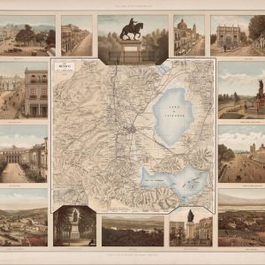
Atlas pintoresco é histórico de los Estados Unidos Mexicanos. Names García Cubas, Antonio, 1832-1912. Source Collection Library of Congress Geography and Map Division Washington, D.C. 20540-4650 USA dcu
- 1
- 2