
Currently Empty: 0,00 €

Historical Aviation Topography This image displays a vintage 1932 United States airway map. It shows the detailed topographical terrain between Kentucky and Ohio. Pilots used these specific charts for ...

Historic Kentucky River Valley Cartography Explore the stunning post-Civil War heritage of the Bluegrass State with this colorful reproduction of the 1871 bird’s-eye view map of Frankfort, Kentucky. Looking ...
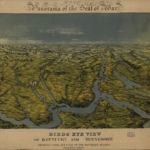
Historical Civil War Panoramic Map Immerse yourself in history with this stunning reproduction of John Bachmann’s 1861 “Panorama of the Seat of War.” This vintage bird’s-eye view map captures ...

Historic Bluegrass Region Cartography Immerse yourself in the rich heritage of the American South with this exquisite reproduction of the 1870 bird’s-eye view map of Paris, Kentucky. Looking southeast, ...

Historical origins of the tactical map This vintage military map displays a 1950 United States Air Force Target Complex Chart focused on Louisville Kentucky. It features detailed regional topography ...
